


 Click here to watch Nyan Sat live!
Satellites? Orbiting MY planet?
If you want to communicate with a satellite, it must be visible in the sky from your location. Whether it's visible to you depends on where it currently is, of course, but some satellites are never visible from some places. Geosynchronous satellites are only ever visible from the half of Earth that faces them, and even some lower orbit satellites might not be visible from your location. It depends on the inclination—the angle between the orbit and the equator.
Orbits with a low inclination stay close to the equator. If you're on the equator, you can probably see them at some point. If you're at a higher latitude, whether you can see the satellite depends on its altitude. Satellites further from the Earth are visible from more places on the ground. LEMUR-2 JOEL, which has an altitude of around 640km, can be seen from Nairobi and Dar Es Salaam when it passes by them, but is never visible from Yerevan. O3B FM8, with an altitude closer to 8,000km, can sometimes (just barely) be seen as far north as Stockholm or as far south as Tierra del Fuego. And yet both are in very low inclination orbits near the equator. The altitude of a satellite in a high-inclination orbit (e.g. a polar orbit) also affects where it is visible, but these will eventually be visible from anywhere if you wait long enough.
What's in an orbit?
Not all orbits are made equal. For the most part, satellites orbit at either Low Earth Orbit (LEO), Medium Earth Orbit (MEO), or Geosynchronous Orbit (GSO).
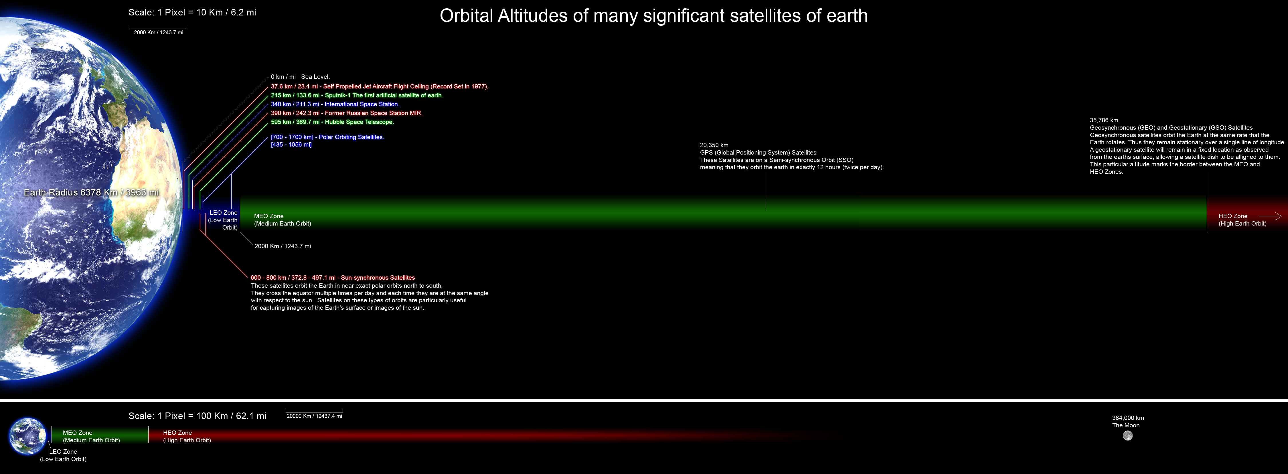 Image author: Mark Mercer CC BY-SA 3.0
Low Earth Orbit satellites are the ones closest to the surface of the earth, within 2,000km. They require the least energy to be sent out into space, and are the easiest to send data to. You'll find things like the ISS and satellites for satellite phones here. The location of these satellites is constantly shifting relative to the surface of the earth - notably, the ISS passes over your longitude once every 90 minutes! They are only visible briefly from any given point on the ground, on the order of around 20-30 minutes at best.
Medium Earth Orbit satellites are ones which fall between Geosynchronous Orbit and Low Earth Orbit. Many of these satellites are between 10,000km and 30,000km (orbits between 2000km and 8000km are not desirable because of high radiation from the inner Van Allen Belt). Most notably, you'll find GPS satellites here. These are still constantly shifting relative to earth's surface, but at a slower rate than LEO satellites. GPS satellites complete an orbit about once every 12 hours.
Geosynchronous orbit satellites orbit once every day, and are 36,000km above Earth's surface. If a geosynchronous satellite orbits at the Earth's equator, it's called geostationary, meaning it always appear at a fixed point in the sky. In a way, it's like they're sitting atop an incredibly tall tower positioned at earth's equator - always visible from that point on earth. These satellites are so far away that sending data to it and receiving a response will take no less than half a second, since that's how long it takes radio waves to travel to and from the satellite.
 Image author: cmglee CC BY-SA 3.0
NASA has more information on different orbits here.
Why track a satellite?
With a directional antenna, signals can be directed such that they're much stronger in one direction than another direction. This is in contrast to an omnidirectional antenna, which sends and receives signals with a relatively constant power in all directions.
A classic example of a directional antenna is a parabolic dish antenna. These work by concentrating a large area on which signals can be received (the dish, called a parabolic reflector) into a smaller point called a feed antenna. The signal is very strong in the direction that the dish is facing, but much weaker in other directions.
 Image author: Richard Bartz CC BY-SA 2.5
Tracking a satellite (moving your directional antenna to follow it around the sky) isn't technically necessary to send or receive a signal. However, lets you use a much more directional antenna. Instead of wasting energy radiating a signal out in all directions, it's much more effective to concentrate the signal in a specific direction. When receiving, the same effect lets you get away with a smaller antenna receiving less total energy, but all of that signal is coming from the direction of the satellite.
Tracking satellites from your location
To learn more about how satellites move relative to your position, you can use the Skyfield library and a public database of satellite orbital parameters to predict when the International Space Station will pass by you. If the sky is not too bright when it does, you can see it with your naked eye. Since it completes an orbit roughly every 90 minutes, it will be moving fast relative to you and won't be visible for more than about 8 minutes at best. If it doesn't pass directly overhead, it won't be visible as long. The further it is from you, the lower in the sky it will be at maximum. If it doesn't get high enough (say about 10 or 20 degrees above the horizon), you may not be able to see it over buildings or trees. You can predict passes well into the future to find one where it will be high enough to see.
A satellite's angle to the horizon from your location is called its elevation or altitude, not to be confused with altitude above the surface of the Earth. Start your calculation now, and calculate its location relative to you every 5 minutes for the next month. When you find a time period when it's above your horizon, narrow down your calculations to that time and calculate its position every 5 seconds. Note the highest elevation. You want a pass where the elevation is high enough to get a good look at it, say at least 45 degrees. The other parameter you are interested in is its azimuth, the direction in which to look. An azimuth of 0 degrees is north, while 180 is south.
We have provided a simple script to calculate the ISS's azimuth and elevation from a point on Earth. It downloads the latest public TLE data that describes satellite orbits and uses this to determine if the ISS is above the horizon in New York City. You can modify it to use your location and calculate the angles at points in the future. It's good to download fresh TLE data frequently, because it goes out of date as satellites change orbits and refine their position. The ISS is moving at upwards of 7km/sec, and at that speed it is hard to be exactly where you want to be. An error of a few km is acceptable for most satellites, but over time those errors add up and you will want to use fresh data. In addition, in low earth orbit the drag of the atmosphere slowly forces a satellite to slow down and lower its orbit, so they need to boost themselves higher periodically.
The principle of tracking a satellite with an antenna is the same. Once you know the azimuth and elevation, this is all you need to point your antenna in the right direction to receive signals.
Bonus points
- Check if the ISS is visible from New York City
- Modify this script to check from other locations
- Modify this script to check other satellites